Turn on suggestions
Auto-suggest helps you quickly narrow down your search results by suggesting possible matches as you type.
Showing results for
Turn on suggestions
Auto-suggest helps you quickly narrow down your search results by suggesting possible matches as you type.
Showing results for
BIM Coordinator Program (INT) April 22, 2024
Find the next step in your career as a Graphisoft Certified BIM Coordinator!
Collaboration with other software
About model and data exchange with 3rd party solutions: Revit, Solibri, dRofus, Bluebeam, structural analysis solutions, and IFC, BCF and DXF/DWG-based exchange, etc.
- Graphisoft Community (INT)
- :
- Forum
- :
- Collaboration with other software
- :
- Re: ArchiTerra
Options
- Subscribe to RSS Feed
- Mark Topic as New
- Mark Topic as Read
- Pin this post for me
- Bookmark
- Subscribe to Topic
- Mute
- Printer Friendly Page
ArchiTerra
Anonymous
Not applicable
Options
- Mark as New
- Bookmark
- Subscribe
- Mute
- Subscribe to RSS Feed
- Permalink
- Report Inappropriate Content
2007-06-29 05:46 PM
32 REPLIES 32
Anonymous
Not applicable
Options
- Mark as New
- Bookmark
- Subscribe
- Mute
- Subscribe to RSS Feed
- Permalink
- Report Inappropriate Content
2007-06-29 06:55 PM
First it is obvious from the AT Dialog box and the program task bar in the Screen shot that you are using AT 3 and AC10. Is it AT version 3.07. Also are you using build (1183) of the AC10 release. (Best to have most of this info in your profile Signature.) I have also had some mixed results so far with the creation of roads using a Fill. If the Fill is fairly rectangular in shape (fills that I used to test with, never get a "clean" shape in real life) then the road generates fine. A fill the I had that as not as clean (the Real-life test), did not generate properly. I am continually attempting to get a good result........
Anonymous
Not applicable
Options
- Mark as New
- Bookmark
- Subscribe
- Mute
- Subscribe to RSS Feed
- Permalink
- Report Inappropriate Content
2007-06-29 08:12 PM
Anonymous
Not applicable
Options
- Mark as New
- Bookmark
- Subscribe
- Mute
- Subscribe to RSS Feed
- Permalink
- Report Inappropriate Content
2007-06-29 10:51 PM
Well.....
Back looking at the Created road (Before any Manipulation), and because I set the slope angle to 33-degrees for any possible fill angle, AT seems to have created a "Fake" Fill and the corresponding contour lines at that angle. Even though not digging or embankment is required.
not a big deal to have a imaginary cut or fill line below the Mesh that is not seen, but because it effects the Contour Tool Object associated with the Mesh., this is a problem.
Anonymous
Not applicable
Options
- Mark as New
- Bookmark
- Subscribe
- Mute
- Subscribe to RSS Feed
- Permalink
- Report Inappropriate Content
2007-07-02 04:00 PM
Anonymous
Not applicable
Options
- Mark as New
- Bookmark
- Subscribe
- Mute
- Subscribe to RSS Feed
- Permalink
- Report Inappropriate Content
2007-07-02 05:51 PM
Anonymous
Not applicable
Options
- Mark as New
- Bookmark
- Subscribe
- Mute
- Subscribe to RSS Feed
- Permalink
- Report Inappropriate Content
2007-07-02 06:42 PM
Case wrote:Case, I think like myself you are not quite understanding the slope Extension and what it's uses. As far as your screen shots, I do not see enough grade change with the road location to see a need for a slope extension. I will send via PM a e-mail I received from Fabrizio about the slope extension. I am still a bit unclear, but he is always great in trying to make thing right.
I gave this a try this morning with two applications noted in the screen shot. Would you agree that the slope extension can't be the same? The first time I tried it the S.E. were both 4" and didn't work. However, I got it to work with different numbers. See image. Any thoughts?
I do not know what you are trying to use the S.E. to accomplish. If you are trying to change the slopes and grade of the road surface I believe that you can raise the road objects nodes in the 3D window. I usually raise the nodes using the Longitudinal section and Rebuild the Mesh.
Anonymous
Not applicable
Options
- Mark as New
- Bookmark
- Subscribe
- Mute
- Subscribe to RSS Feed
- Permalink
- Report Inappropriate Content
2007-07-02 06:55 PM
Anonymous
Not applicable
Options
- Mark as New
- Bookmark
- Subscribe
- Mute
- Subscribe to RSS Feed
- Permalink
- Report Inappropriate Content
2007-07-02 06:56 PM
Case wrote:Again on a mesh as "flat" as this one appears, I do not see that you will see any Diggings or embankments no matter what value angle they are set to.
here is another example
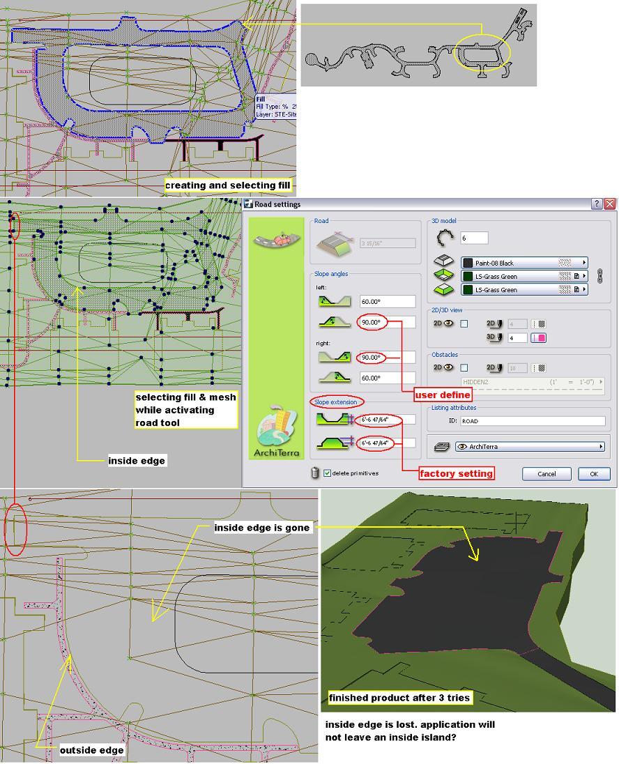
As far as the middle of the road getting "filled-in", I would be curious what fill lines you are using as your road ends. this Circular type of road may have to be at least two different segments (Fills). In my previous post you can see that I have broken my road way into segments, Orange fill color and 'green' color. I also previously had fillet radius' at almost all of the corners. The curved sections are not represented properly in the Longitudinal Section, so for the most part for now I have decided to model the Roads with sharp 90-degree intersections with connecting roads. This is not real life, but AT is a nice tool for what I am doing. For proper coverage calculations and 2D representation I have a fill that represents the Rood surface and this fill will show the proper radius intersections. I would like to send you a few other copies of e-mail questions that I have for Cigraph if you do not mind. PLease send me PM with e-mail address. Or I will do the same.
Anonymous
Not applicable
Options
- Mark as New
- Bookmark
- Subscribe
- Mute
- Subscribe to RSS Feed
- Permalink
- Report Inappropriate Content
2007-07-02 07:04 PM
Learn and get certified!

Still looking?
